Entry to USA
Please be sure to check your own government’s information as well as the U.S. State Department website to confirm passport and visa requirements where applicable. See the “Visa Wizard” on this page: https://travel.state.gov/content/visas/en.html (the B-1 business visa appears to be the one covering travel to professional meetings, etc). For some nationals, you may instead apply for entry authorization under the Visa Waiver Programme (VWP): https://esta.cbp.dhs.gov/esta/
Getting to D.C.
The tendency to identify places by abbreviated terms extends to the usual names for the three airports that serve the area: National, Dulles, and BWI.
“National” (DCA) is officially named the Ronald Reagan Washington National Airport, but you’ll find many people simply calling it “National” or perhaps “Reagan.” It is the airport closest to the city, and is located on the Blue and Yellow Metro lines. Almost all flights into and out of DCA are domestic, though a few flights have Canadian destinations. (The relatively short runway limits the types of aircraft that can use the airport.)
“Dulles” (IAD), one of the two international airports, is located about 26 miles west of Washington DC. http://www.flydulles.com/iad/directions-maps
Transportation to and from the airport can be via public transit, such as a combination of bus and Metro rail service: http://www.flydulles.com/iad/silver-line-express-bus-metrorail-station.
Alternatively, there are shared-ride vans bringing you door-to-door for fixed prices: http://www.flydulles.com/iad/shared-ride-van-services
The other international airport is Thurgood Marshall Baltimore-Washington International [BWI], located about 30 minutes northeast of DC by highway. Transportation to and from BWI is often by rail, either the regional commuter line (MARC) or the AMTRAK trains that come through the airport rail station. http://www.bwiairport.com/en/travel/ground-transportation. Also available is the shared-ride Supreme van service.
Amtrak train service brings people to Union Station, Amtrak's headquarters and the railroad's second-busiest station. The building, an architectural monument in itself, is only four blocks from the Library of Congress and is the starting point for many sightseeing tours:
https://www.amtrak.com/home
http://www.unionstationdc.com/
http://www.unionstationdc.com/info/sightseeing
Getting Around in DC: Public Transit
Most IASA events will take place close to Metro stops on the shared Blue/Orange/Silver lines that pass through the center of the city. http://www.wmata.com/rail/maps/map.cfm
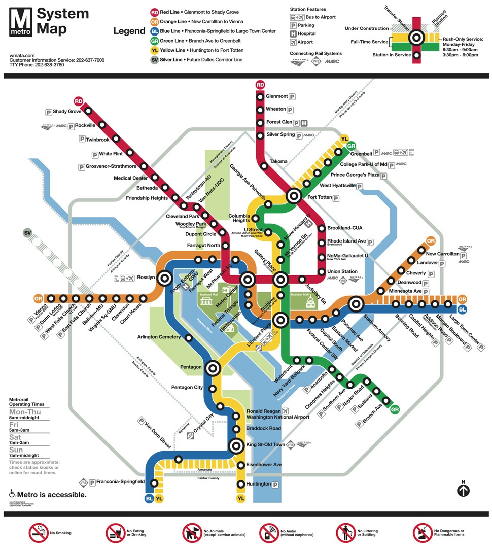
Consult the Washington Metropolitan Area Transit Authority (WMATA) website for information on how to purchase a SmarTrip Card and how to use the system: http://www.wmata.com/rail/? (SmarTrip cards are also usable on the city’s buses.)
Throughout the conference, if you’re traveling around the Washington area by MetroRail, please keep an eye out on the WMATA website for information on any delays, etc. The system is undergoing extensive maintenance so the “Alerts & Advisories” site can be helpful: http://www.wmata.com/rider_tools/metro_service_status/rail_Bus.cfm
And if you find yourself on one of the many long escalators in the MetroRail system, please note that the protocol is “stand right; walk left” (Washington’s regular commuters frequently walk up and down the escalators).
You may wish to check the WMATA “real time arrivals” information for whatever station you are at: http://www.wmata.com/rider_tools/pids/real_time_arrivals.cfm
Please note that the Metro rail system closes at midnight every night.
Circulator Buses
See also the information about Circulator buses whose routes cover many D.C. neighborhoods as well pass near major D.C. attractions:
http://www.dccirculator.com/
Bicycles for rent
Capital Bike Share: https://www.capitalbikeshare.com/